
When we talk about the Canary Islands, the first image that normally comes to mind are the characteristic palm trees of the islands and the white sand of some of its beaches. So together with my travel companion I decided to live in first person the experience of visiting each of the Canary Islands. We prepared an ideal trip to get to know the paradise that is the Canary Islands.
On this trip we didn't just relax on a beach, we also went on an adventure, taking in much of its volcanic relief, picturesque harbours and colonial architecture.
Each of the islands offers a different and unique experience, and below I will show you a part of my adventure in the Canary Islands.
La Palma
DAY 1: ARRIVAL IN LA PALMA - SAN ANDRÉS Y SAUCES.
We landed at the airport in the city of La Palma, picked up the rental car and headed to the hotel, located in Santa Cruz de La Palma, to leave our luggage and check in, and finally get ready to get to know this wonderful island.
We start this adventure with a stroll through the city, where we visit the Calle Real along with the Avenida Marítima, which stands out for its typical balconies, Calle Virgen de la Luz and Calle San Sebastián, where we find a series of valuable buildings and corners.
In its surroundings we find the presence of museums, churches and buildings of great architectural beauty; such as the Church of Santo Domingo; the main parish church of El Salvador; Plaza de España. In addition, Santa Cruz has a great variety of bars and restaurants, where, of course, traditional dishes are a must.
After a good meal, we headed to a village we were looking forward to visiting, San Andrés y Sauces. There we visited an important historical centre, the Church of San Andrés Apóstol, located in the Plaza de San Andrés, one of the oldest churches in the Canary Islands. Something very curious is that this church has a murky legend, in which it is said that Maria Liberata de Guisla was buried alive in the crypt of the chapel dedicated to Our Lady of the Rosary.

Continuing with the tour, we see that in the Calle de la Iglesia and throughout the small village we can see the houses of the wealthiest families, some of the oldest buildings on the island, examples of traditional and popular Canarian architecture with their thick stone and clay walls. We also visit other buildings of special historical and cultural value such as the Pilar Chapel, the San Sebastian Hermitage and the Old Cemetery and Calvary.
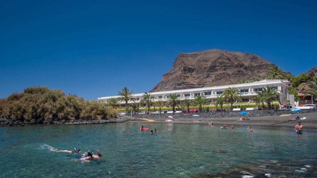
From there we took a walk along the coast to Charco Azul, one of the most popular tourist sites, which consists of a large natural swimming pool, protected from the waves, and with all kinds of services.

DAY 2: CALDERA DE TABURIENTE NATIONAL PARK - CASCADA DE COLORES.
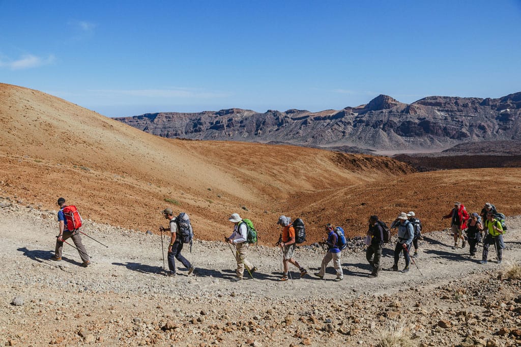
This day we enter the heart of the island of La Palma, the Caldera de Taburiente National Park, an area of volcanic nature with a caldera of 8 km in diameter and a large amount of water resources. On this spectacular trail we find waterfalls, pastoral shelters, plantations of various crops, dams, canals and a small power station, jewels of the island's industrial heritage.
The first thing we did was to get to the car park of the village, where we left the car parked and took a taxi to get to the viewpoint of Los Brecitos, the most used starting point to enter the Caldera de Taburiente.
The Caldera de Taburiente route was a fairly comfortable descent, surrounded by dense vegetation. On the way down we came across some curious ravines (Ciempiés, Las Cañeras, Las Traves, Piedras Redondas). Then we came across a sign announcing the presence of Playa de Taburiente.

After passing through Taburiente Beach we arrive at the camping area, with plenty of space, toilets, a mini interpretation centre of the Caldera.
It was a slight ascent to begin the steepest and steepest descent of the entire route: we headed towards the Barranco de las Angustias ravine. On the way we saw the mythical Roque Sagrado Idafe from different points, rivers descending ravines, man-made waterways, until we reached one of the great attractions of the Caldera de Taburiente route, the spectacular Cascada de Colores waterfall.
There were still about 5 kilometres of road to go to reach the starting point, a road that was slowed down by having to walk between rocks and avoid the small stream that runs towards the coast, but we made it!

DAY 3: KAYAK THROUGH THE WESTERN COAST
This third day on the island we wanted to do an activity different from the previous days, a fun kayaking adventure, starting from the beach of El Remo.
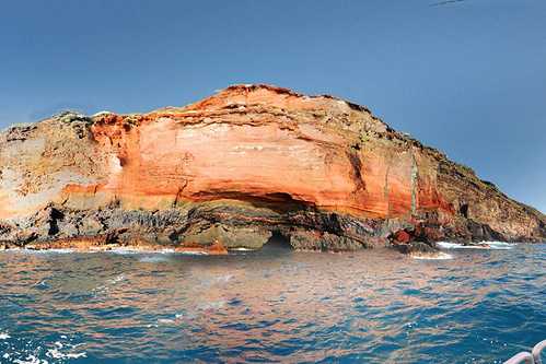
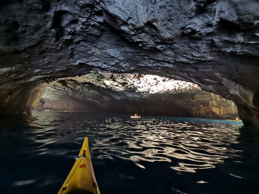
This activity lasted 3 hours, during which we sailed along the west coast, enjoying every corner, beach and cave of this fantastic place. We were able to see dolphins, the small port of Puntagorda, Cueva Colorada, Cueva Bonita, Poris de Candelaria.
THE IRON
DAY 4: BOAT TO EL HIERRO - ROUTE BY CAR FROM SAN ANDRÉS TO VALVERDE.
We continue our journey and arrive at the next island, El Hierro, the smallest island of the Canary Islands, but which still conserves impressive corners.
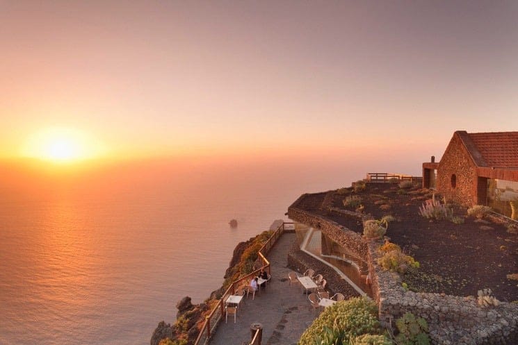
As soon as we arrived, we picked up the car and headed for our accommodation. We had planned our first activity on the island, a drive from San Andrés to Valverde. Our first stop was the viewpoint of La Peña, designed by César Manrique, which offers impressive views of El Golfo and the Roques de Salmor.
Our next stop was the picturesque village of El Mocanal, surrounded by pastures and crops, an eminently agricultural village that offers a very special charm, with corners that keep their traditional architecture intact, narrow and small streets and squares that show the slow passing of El clima.

Finally we arrive at Valverde, a town that brings together most of the key administrative centres, streets and houses with heritage value, as well as serving as a commercial reference point. In the historic centre of Valverde we find sloping streets and picturesque squares, the most outstanding buildings such as the Church of La Concepción or the Town Hall with typical Canarian architecture.

Our tour took us to the Puerto de la Estaca, where the entrance to the island by sea is located, and 15 minutes away is the Playa de la Arena.
DAY 5: LAURISILVA DE LA LLANÍA FOREST
Today's adventure is a hike on one of the most popular trails on the island of El Hierro. This walk lasted approximately 2 hours, where we discovered the beautiful landscapes that this amazing island hides.
Your journey began at the car park, entering El Brezal, a truly fairytale green setting, a dense, damp forest, leading to fern-lined trails that lead to softer, bare ground and the black sands of one of the island's best-preserved calderas, which precede the grandiose landscape of the Gulf. It's a seven-kilometre round trip with plenty of magic and beauty.
We particularly liked two viewpoints on this trail: the Fireba viewpoint, with incredible views of the caldera of the same name; and the La Llanía viewpoint, with dizzying and spectacular views of the El Golfo valley.

DAY 6: NATURAL MONUMENT OF THE BEACHES
We approached the Las Playa Natural Monument, as we had heard a lot about it. It is located in the southeast of the island, belonging to the municipalities of Valverde and Frontera. There we enjoyed one of the most amazing landscapes of the island.
The views overlooking this great valley are truly astonishing, whether from the viewpoints of Las Playas and Isora, which are located at the top, or from the beaches themselves.
In the vicinity of the Las Playas Natural Monument we find the Canary Island pine and juniper, which are usually accompanied by groups of rockroses or elegant shrubs.

LA GOMERA
DAY 7: BOAT TO LA GOMERA - TREKKING IN GARAJONAY NATIONAL PARK.
Our next destination was the island of La Gomera, and as on the previous islands we hired a car and once we had checked into our accommodation we headed for the Garajonay National Park.
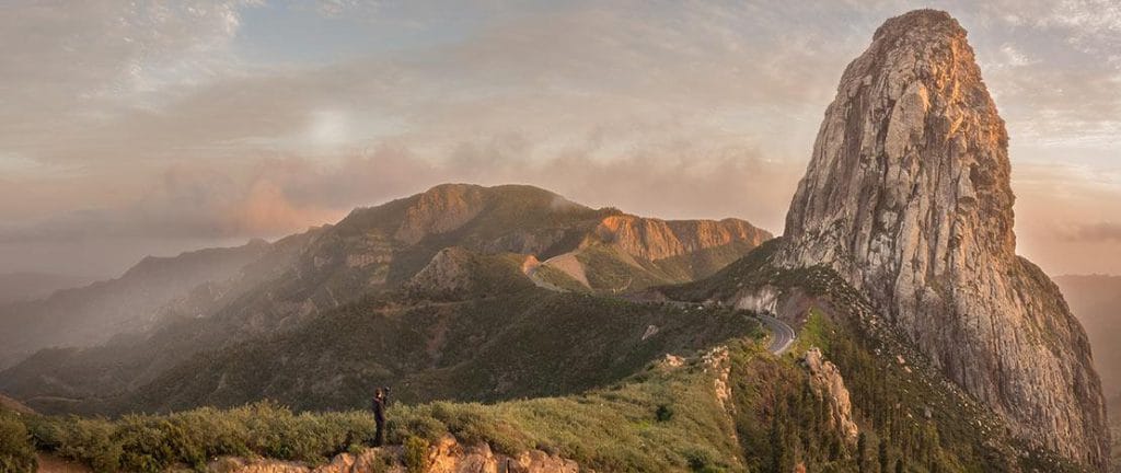
Garajonay, listed as a National Park and World Heritage Site, is located at the top of La Gomera, on the central "plateau". Something very curious about this heritage site is that it protects some 4,000 hectares of a unique forest ecosystem, the laurel forest, because, in the Tertiary period, Europe suffered a glaciation and North Africa a desertification that led to the extinction of most of the subtropical flora of the Mediterranean basin. Due to its temperate climate, the tertiary flora survives as a living fossil on La Gomera.

DAY 8: VALLEHERMOSO - VIEWPOINT OF LOS ROQUES - VIEWPOINT OF ABRANTE
We start our day visiting Vallehermoso, a town with interesting examples of traditional architecture, and where the popular church of San Juan Bautista is located. This town is located in the west of the island of La Gomera, stretching from the north to the south of the island.

Afterwards, the Mirador de Los Roques, a place that offers impressive views, with a spectacular sunset and a sea of clouds, which you won't be able to resist taking a thousand photographs of. Also, if conditions permit, you can see the Teide from there.
Another viewpoint is the Mirador de Abrante, which not only has spectacular views but also made us feel like we were flying thanks to its 7-metre glass walkway, with the hundreds of metres high cliffs below our feet. If you visit this place you will love its 360º panoramic view, contemplating the Agulo Valley and in the background the neighbouring island, Tenerife, with its spectacular silhouette of the Teide. Taking advantage of the proximity, we pay a quick visit to the picturesque Agulo.

DAY 9: PLAYA DEL INGLÉS - PLAYA DE LA CALERA - CHARCO DEL CONDE
Today we are located in the south of La Gomera, getting to know its best beaches. We start with Playa del Inglés, said to be the best beach on the whole island of La Gomera, located in the southwest corner of the beautiful Valle Gran Rey. This beach is characterised by its volcanic sand and the beautiful natural landscape that surrounds it, and being a naturist beach, nudism is allowed. The waves on this beach are medium, so be careful.

Another beach we had to visit was Playa de La Calera, the longest sandy beach on the island of La Gomera, a characteristic of which is the calmness of its waters, which makes it an ideal place to go with the family ... .

Finally, we end the afternoon in Charco del Conde.
TENERIFE
DAY 10: BOAT TO TENERIFE - SANTA CRUZ DE TENERIFE - SAN CRISTÓBAL DE LA LAGUNA.
Tenerife was waiting for us and we were looking forward to it. We stayed in Santa Cruz de Tenerife, and without wasting any time we set off to explore its streets.
We start walking through the city centre of Santa Cruz de Tenerife, with the Plaza de España as our first stop. From there you can appreciate the view of the square towards the mountains, the artificial lake, the Central Monument and the large sign at the end of the square next to the lake. During the tour, we come across the Iglesia Matriz de Nuestra Señora de la Concepción, the Puente del Cabo and the Museum of Nature and Archaeology, until we finally reach the TEA Espacio de las Artes, a cultural area that houses various exhibition halls, the Tenerife Island Photography Centre and the library of the Island Network.
Afterwards we go out on Av. De San Sebastián, and visit the Mercado de Nuestra Señora De África, a market with a variety of flower stalls, organic and homemade produce stalls, at very affordable prices. Then we go to Avenida Tres de Mayo, where you will find the Skyscraper, the El Corte Inglés shopping centre, the Nivaria Centre, the Santa Cruz de Tenerife Interchange.
After a short rest, we resume our walk and head for the Auditorio de Tenerife, an incredible building that has become a symbol of the city, and where you can enjoy beautiful views of the sea.

On the other hand, we also wanted to see La Laguna, so we headed there.
La Laguna is possibly the city of choice for leisure within the metropolitan area. Its narrow streets for walking, its wide squares for children to spend hours playing and adults on a bench to let the time pass, the variety of cafes, bars and restaurants that can make anyone dizzy, the eternal nightlife. La Laguna may not be the capital of Tenerife, but it is one of the main destinations in the north of the island.
There we saw emblematic, public and historic buildings such as the Town Hall, the Courts and the Hermitage of San Miguel, as well as the Convent of Santa Catalina, whose balcony takes centre stage as the perfect place to see without being seen.
We then moved on to Calle Herradores, one of the most attractive streets in La Laguna and also part of the Plaza del Adelantado.
One of the advantages of La Laguna is that, walking aimlessly or not, you'll end up on a pedestrian street that will leave you spellbound by all it has to offer. In this case, we turn onto Calle San Agustín, which, in the opinion of many, is one of the most beautiful and impressive streets in the whole city. On this street there are also several stately homes, some of which have already been converted into museums or the headquarters of different estates in La Laguna. Just a few steps away from the Episcopal Palace, and on Calle San Agustín itself, we find the Museum of History and Anthropology of Tenerife, which occupies the Casa Lercaro and the Casa Saavedra.
We also visited one of the most representative symbols of La Laguna, the Church of Nuestra Señora de la Concepción.

Which plan to follow on your holidays?
Don't miss the Experience Teide peak excursion: on foot or by cableway
Get to know the most visited national park in Europe and climb the highest peak in Spain. Exceed your limits on this excursion of ascent to Teide peak with permits.
If you want to live a unique and environmentally friendly experience, and also get to know the Teide National Park with a Senda guide, which has been declared a World Heritage Site by UNESCO, then this is the place for you. Unesco World Heritagebook your place for a guided visit to Teide with permits.
DAY 11: VISIT TO LA OROTAVA - STARGAZING IN THE TEIDE NATIONAL PARK
This day we wanted to rest and recharge and start this new adventure in the afternoon.
Our activity took place in the north of Santa Cruz de Tenerife, as we wanted to visit the historic centre of La Orotava, as it concentrates a great variety of heritage points of interest.
At first glance, the place is charming. We find the Carpet Museum and the Casa de los Balcones, which is considered the most important handicraft complex of fretwork in the Canary Islands.
Our first stop began at Casa Ponte Fonte, popularly known as Casa Lercaro, a clear example of typical Canarian architecture.

Regardless of where we are or where we are going, there is always something to see in La Orotava, in this case we went to the famous and spectacular Victoria Garden, a place you definitely can't miss if you visit this island, but on the way we came across the Iglesia Popular Nuestra Señora de la Concepción, the Plaza Patricio Casañas and the Biblioteca Pública Municipal.
All in all, El Valle de La Orotava is possibly one of the most beautiful sights to be found in Tenerife. The Victoria Gardens are located within the old town, next to the Plaza de la Constitución and the Liceo Taoro. Once we arrived at Victoria Gardens, we learned a bit about its history, enjoyed a beautiful panoramic view, and without a doubt, we fell in love with this place for its beautiful flashing fountains and the multitude of colourful flowers.

Then the Plaza de la Constitución together with the Church of San Agustín, are public spaces of great importance. From the square you can also see the Liceo Taoro where we conclude this walk through the historic centre of La Orotava.
At nightfall we experience the astronomical observation of this island from the Teide National Park, far from the pollution of urban centres and under one of the best skies in the world.
Thanks to the high-end telescopes we could feel closer to the wonders of the Cosmos; stars, nebulae, galaxies... and of course, enjoy the view of our neighbours in the solar system, especially Jupiter and Saturn.

DAY 12: SNORKELLING WITH TURTLES AND CETACEANS ECO EXPERIENCE - KAYAKING ON THE CLIFFS OF THE GIANTS
In the morning our activity would be snorkelling with turtles. We left from Puerto de La Galletas, in a boat that took us along the south coast of Tenerife. The boat trip included an interpretation related to the marine and terrestrial ecosystems of the coast of this area of the island and we were accompanied at all times by an expert instructor who gave us all the instructions related to the activity.
We snorkelled for an hour, surrounded by sandy beaches, reefs and an attractive aquatic moonscape. Sweet tabaibas, pineapples and sea lettuce, kestrels, thyme warblers, catalufas and moray eels are some of the many species you will have the opportunity to see.
Later in the afternoon a kayaking experience awaited us at the Los Gigantes Cliffs.
The activity started in the Marina de Los Gigantes. This is undoubtedly one of the most fun activities on the south coast of Tenerife. Skirting the imposing natural vertical walls of the south of the island, we discovered the secrets that this incredible place has to offer, always accompanied by expert monitors, who not only guided us, but also showed us their favourite spots along the way.
The activity lasted about an hour and a half, where we paddled in a calm sea and enjoyed the seabed while diving.

GRAND CANARY
DAY 13: FLIGHT TO GRAN CANARIAS - VISIT TO LAS PALMAS DE GRAN CANARIAS.
To leave for Gran Canaria this time we took a flight, whose airport is located near Telde, in the Bay of Gando, 19 km from the city centre of Las Palmas. Once we landed, we picked up the rental car and headed for the city of Las Palmas, as our accommodation was in the city centre.
Once we had left our luggage at the hotel, as in previous destinations, we set out to explore the city. Here we saw the Ermita de San Antonio Abad, the Plaza Santa Ana, where the Town Hall, the Bishopric, the Casa Regental and the Cathedral of Santa Ana are located, which are just some of the traces of history that have remained for centuries . . .

We also visited the Casa de Colón, where we learned about the most interesting aspects of Christopher Columbus' voyage to America and his stay in the city. As for the Museo Canario, we can say that it is the ideal place to go if you want to get to know all the peculiarities of the island, as it conserves, studies and exhibits collections of archaeological and ethnographic materials and artistic creations, together with a library and archive on Canarian aboriginal themes.

We then enter the Pérez Galdós Theatre, one of the city's emblematic buildings. We also stroll through the Plaza de Hurtado de Mendoza and the Plaza de Cairasco, one of the meeting points of the Triana neighbourhood, where two outstanding buildings are located: the Hotel Madrid and the Gabinete Literario, in neoclassical style and modernist decoration. .

DAY 14: MASPALOMAS DUNES.
The activity took place in Las Dunas de Maspalomas, a natural area located in the municipality of San Bartolomé de Tirajana, in the south of the island of Gran Canaria.
We parked the car near the Hotel Riu Palace Maspalomas and decided to set off on our journey. From there we take a path whose branch number 3 crosses the different types of dunes of the reserve and arrives at the extensive and sunny beach of Maspalomas, where we can observe the abundant fauna of La Charca and enjoy the refreshing shade of the Palm Grove.

From here we went for a pleasant walk to Playa del Inglés, one of the most famous tourist beaches on the island, where we spent the whole afternoon.

DAY 15: VIEWPOINT OF THE PEAK OF LOS POZOS DE LAS NIEVES- ROQUE BENTAYGA.
For this route we have taken as a reference point the Cruz de Tejeda, where the only Parador Nacional of Gran Canaria is located, and we can access the Mirador del Pico de Las Nieves.
You can park your vehicle in the limited parking spaces available.
As soon as you get out of the car, the viewpoint offers a spectacular panoramic view of the centre and west of the island. The imposing presence of Mount Teide stands out in the background. From there you can see the two most representative rocks of the summit of Gran Canaria, the Nublo and the Bentayga.

Our second place was Roque Bentayga, where we enjoyed spectacular views of the Sierra Sagrada de Gran Canaria, declared a World Heritage Site by UNESCO. At the foot of Roque Bentayga, next to the car park, we visited the Interpretation Centre.

DAY 16: DEDO DE DIOS BEACH - BALCONY VIEWPOINT.
This day we wanted to relax, and what better way to do it than at the Dedos de Dios beach.
The Dedo de Dios of Gran Canaria is located in front of the Agaete quay in the oldest geological area of the island. Its original name is Partido de Roque, but the writer Domingo Doreste 'Fray Lesco', renamed it Dedo de Dios (God's Finger) because of its appearance of an index finger pointing to the sky.

After a relaxing afternoon on the beach, we wanted to visit the Mirador del Balcón, to appreciate the sunset. This offers spectacular views of the cliffs of Gran Canaria.

FUERTEVENTURA
DAY 17: BOAT TO FUERTEVENTURA - PUERTO DEL ROSARIO. - WHITE BEACH. - (FUERTEVENTURA)
We arrived in Fuerteventura and wanted to start our adventures. We started in the capital, Puerto del Rosario. There we took a walk along the Paseo Marítimo of the municipality, where, in addition to enjoying its excellent and pleasant views, we went through one of its busiest areas.
Then we headed to La Casa Museo de Unamuno, which is one of the emblems of the city. This museum is located in the old Fuerteventura hotel, which was the place where the writer decided to stay for more than three months, after being exiled from the peninsula for not thinking and questioning Spanish politics during the rule of Primo de Rivera.
And then we took a stroll along Calle Primero de Mayo, the pedestrian centre of the city. In this street we found a great variety of shops, restaurants and terraces. From here you can start to explore the different places of interest in the town.

Near Puerto del Rosario is Playa Blanca, and given its proximity we decided to visit it and spend the afternoon there.
DAY 18: CALDERÓN HONDO VOLCANO
We leave the hotel early in the morning to go to the Calderón Hondo Volcano, one of the best places on the island to see such spectacular scenery, located near the village of Lajares, only from there you can admire the alignment of volcanoes that expanded the island of Fuerteventura to the north, forming the island of Lobos.
There are two main routes to Calderón Hondo. One of them, the most accessible, is only 3.7 kilometres long and starts in Lajares. The other route starts in Corralejo, and is just over 9 kilometres long. In this case we took the Lajares route. In it, there are several viewpoints and informative signs where, in addition to offering curiosities of the area, it guided us all the way.
The round trip, with 2 rest stops, took about 2.5 hours. To find the start of the route, take the road from Lajares to Majanicho, which starts at the Campo Municipal de Fútbol de Lajares.
The trail skirts the foothills of Montaña Colorada where you can see the hollows in its slopes that correspond to a picón quarry. After 3 kilometres from the start of the hike, the path forks; on one side, the path turns right towards Corralejo, while the local path FV 2 turns left onto a cobblestone road. After a few metres the path splits again; to the left the path leads to the summit of Calderón Hondo, while if we turn right the path will lead us across the moors to the foot of Caldera Rebanada.
On the edge of the Calderón Hondo crater there is a railing and a small observation area, where the local council has installed one of the 8 landscape binoculars that exist in Fuerteventura, this one specifically looks from the Calderón Hondo towards the Malpaís de Bayuyo, Corralejo, Isla de Lobos and Lanzarote. With this prismatic landscape, we can appreciate in great detail, the shrimps that were built, or the area of the caldera, paths and tracks that the goats once walked along, etc.

DAY 19: JANDÍA NATURAL PARK - COFETE BEACH - SOLEDAD BEACH.
Today we wanted to visit one of the most spectacular places in the Canary Islands, the Jandía Natural Park, which is located in the south of the island of Fuerteventura. It is a natural area of extraordinary beauty, with the best beaches of the island and possibly of the Canary archipelago.

Nearby is the beach of Cofete, one of the best beaches of Fuerteventura. The weather was good and we took advantage of the sea in the morning. Then we went to the beaches of Los Ojos and Soledad, two beaches with golden sand and isolated from the populated areas. Unfortunately, Playa de Ojos is not safe for swimming, as it has a strong swell and many rocks, access is complicated by the cliffs, although it is a paradisiacal place to enjoy a relaxing day at the beach.
DAY 20: BETANCURIA RURAL PARK - GUISE AND AYOSE VIEWPOINT - LAS PEÑITAS VIEWPOINT - AJUY NATURAL MONUMENT.
This day we wanted to explore the volcanic landscapes that are so characteristic of the Betancuria Park, a route that allowed us to learn a little more about the geology of the interior of Fuerteventura.
The rural park of Betancuria forms 91.2% of the territory of the municipality, being a protected area for its geomorphological and ethnographic values. The Betancuria Massif is one of the most spectacular outcrops of the Basal Island Complex, with a high scientific and scenic value.
During this hiking route through the Betancuria Rural Park, we covered 10 kilometres of low difficulty round trip, with an approximate duration of three hours. We followed the route that runs through the mountain that separates Antigua and Betancuria, whose terrain is characterised by its captivating natural landscapes of volcanic origin.

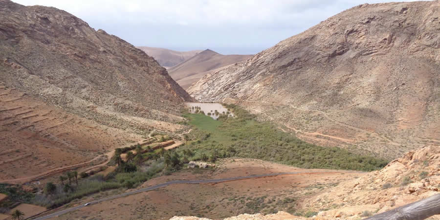
On this route we visited the viewpoint of Guise and Ayose, which was located between the Santa Inés Valley and Betancuria. From there, there are views of the northern landscape of the island towards El Cotillo and in the southern area to the town of Betancuria, as well as a monument with the statues of the two kings or menceys, Guise and Ayose, which is located at the viewpoint. The sculptures are made of bronze, almost 4 m high, the work of Emiliano Hernández.

Another point was the Mirador de Las Peñitas, located between Betancuria and Pájara. From this point you can see the ravine and the Las Peñitas dam. To the left is the Valle de los Granadillos, and if we turn to the opposite side of the dam, we can see the Pico de la Muda, which is 538 m high.
Then we reach the Ajuy Natural Monument, which is located at the mouth of the Ajuy Ravine.
Ajuy is an unbeatable observatory for what is described, as it is the oldest place in the Canary archipelago. In this fishing village you can also find the Caves of the same name, where you can see limestone deposits, dykes, landslides and much more.

LANZAROTE
DAY 21: BOAT TO LANZAROTE - HIKE TO TIMANFAYA NATIONAL PARK - HIKE TO CUERVO VOLCANO - GREEN LAKE.
Arrival at César Manrique airport. Delivery of the rental car and check-in at the hotel.
Our first activity on the island of Lanzarote will consist of a fun walk through the Timanfaya National Park, originated after the violent volcanic eruptions that took place in the south of Lanzarote between 1720 and 1824, where we learnt a bit of the past, enjoyed the geothermal demonstrations and were able to appreciate one of the most picturesque visual spectacles of the Canary Islands. On this hike we encountered fascinating volcanic landscapes, which made us feel as if we were walking on the moon but without leaving the earth.

Then we hiked to the Cuervo Volcano, a route with a geological focus, composed of characteristic elements of the volcanic landscape of Lanzarote, where we were even able to access the crater of the volcano itself. This hike was of little difficulty, a simple 6 km round trip.
And finally, we could not miss El Lago Verde, an ancient volcanic crater into which seawater has seeped. It is located in the Natural Park of the Volcanoes that surrounds the Timanfaya National Park in the town of El Golfo, in the south of the island of Lanzarote.
DAY 22: KAYAKING ON PAPAGAYO BEACH.
A fun day awaited us, where we got on board the kayaks, which we paddled to Papagayo beach. This activity allowed us to get to know the marvellous coastline of the Los Ajache Natural Monument.

DAY 23: LA GRACIOSA ISLAND
Of course, the island of La Graciosa could not be missed, your visit is a must. This day we set off for the island of La Graciosa, which is 30 minutes away from Lanzarote by boat.
This island is located to the north of Lanzarote and forms part of the Chinijo archipelago, and a fact you should know is that La Graciosa has no roads, so in our case we took a trip in a taxi-jeep in which we saw the fabulous beaches: Playa Los Hervideros, Playa Lambra and Playa Las Conchas.
Right at the foot of Playa de las Conchas is Montaña Bermeja, another of La Graciosa's volcanic groups, where of course we admire its spectacular views of the whole island.

DAY 24: AROUND LA GERIA
On this last day in the Canary Islands we visited La Geria, known as the Wine Route of Lanzarote, one of the most visited and photographed places for its attractive and unique landscape.
La Geria is located within the municipality of Yaiza, bordering the Timanfaya National Park. This natural environment is characterised by the cultivation of vines in the holes dug in the volcanic ash itself, by its internationally renowned wine production, and by the fascinating contrast between the blackish soil and the green vines. During the tour we were shown the process of vine cultivation, from planting to harvesting, and had the opportunity to taste the island's famous Malvasia grape wines and cheeses at La Geria and the El Grifo Museum.
One of the oldest wineries is the bodega El Grifo, and there we observed curious tools and machinery that have extracted the best possible wine from the grapes of Lanzarote. This tour was undoubtedly like a journey through the history of wine on the island over the last three centuries.

Add comment